
Hi everyone – thanks for waiting. Now the story begins.
You may recall that before I left the world of mobile communications what now seems a long time ago on the 4th November I had recounted our first 2 days of trekking. On day 1 (Wed 3 Nov) we had flown into Jomsom. Following some last minute foraging for a second sleeping bag for Lizzie and my trekking lifesavers (half a dozen Snickers bars) we trekked north to Kagbeni. This stretch was a fairly modest 12 miles or so but we were getting used to the altitude and each other and this takes time.
The others? Ah yes, maybe this is a good time to introduce the team. We numbered 5 trekkers and 4 Sherpa porters.
Our lead Sherpa and guide is Gyalbu Tamang. Gyalbu is a long-term associate of Tim’s and they have worked together many times. Gyalbu suffered very serious injury and family loss when his home in Langtang was destroyed by the Nepalese earthquake (the Gorkha earthquake) in April 2015 but his strength, fortitude and determination and the skill of a surgeon has shone through and he now works as a guide again in Nepal and Japan. Our second Sherpa is Gyalbu’s elder brother Sangye Tamang. The support pair are friends of Gyalbu about which more in due course.
Other than myself the trekkers comprise Tim Calder, Liz Roberts, Jovan Ilic and Mark Pearson. Tim is my friend and mountaineering buddy previously based in the Lake District but now living in Vancouver. We climbed on Cho Oyu together in 2013 and, but for the Good Friday avalanche in April 2014, we would have attempted to climb Everest together that season. This trek is Tim’s brainchild and without his planning and contacts it would not be possible. Liz (Lizzie) is a broadcast journalist from Chesterfield on a career break from her job as political reporter at BBC Radio Sheffield and BBC Sunday Politics on Yorkshire TV. Lizzie has trekked with Tim before. Jovan (Jovi) is a firend of Tim’s. He lives in Kathmandu and is the acting Country Director at the British Council Nepal. Mark Pearson is not known personally to the others but has worked with Jovi’s wife and comes highly recommended. He is a trekking nut who has walked in Cambodia, Vietnam and Burma, among other places. When not trekking Mark consults on health advisory matters and is based in the south of England.
So to the trek. The height gain from Jomsom to Kagbeni was a mere 100m and the walking was easy. But as we were already approaching 3000m (9843ft) above sea level we could already feel the effects of altitude in our breathing on even the most of gentle inclines. The walk east to Jharkot and back on Thu 4 Nov assisted our preparation. This meant that despite maybe enjoying 1 or 2 beers too many and some glasses of the local moonshine known a Arak (or Raksi – pronounced Roxy) in the evening we were broadly in good shape to get the real trekking business underway the following day.
Raksi is a traditional distilled Nepalese moonshine which is often made at home. It is usually made from kodo millet and different grains produce different flavours although it commonly resembles Japanese saki in appearance and flavour. As it is not licensed it can be very strong in aroma and taste. I love CNN’s description of Raksi: “It sends a burning sensation straight down your throat which resolves itself into a surprisingly smooth, velvety sensation. Nepalese drink this home brew to celebrate festivals, though some think that the prized drink itself is the reason to celebrate.” The most notable feature of Raksi in my (limited) experience is that the drinker experiences no gradual degradation of lucidity or function. All is well through the happy stage until sudden, complete and utter system failure. ‘Nuff said (for now anyway).
On day 3 of the trek, Friday 5th November, we left Yac Donalds at just before 8 am following a good breakfast of porridge, eggs, toast, jam and lots of tea. The sun was still low in the sky so the eastern-facing buildings were in brilliant sunshine while those facing west remained in deep shadow. The air was chill and most of the team had donned thick jackets but had already applied suncream in anticipation of the hot day to come. I alone was in short sleeves following the adage ‘be bold – start cold’. I seem to operate at a higher temperature than many and even in the morning chill I was fine in light beige trousers, a red/grey trekking t-shirt and an old faded red The North Face (TNF) baseball cap with ‘a foreign legion-style’ drape on the back and sides as sun protection, together with sunglasses. (I bought this hat in 2014 in Namche Bazaar on the way to Everest basecamp and it is well past its ‘use by date’ but its a favourite I can’t part with having left its predecessor on the summit of Aconcagua a few years previously). I would soon warm up despite my 35 litre Lowe Alpine rucksack weighing a mere 8kg or so and if not I had extra layers to hand.
Our loads were light as Tim and Gyalbu had secured 3 ponies and their horseman/handler to assist with the load carrying over the first few days. This meant that the Sherpa loads were relatively light, although probably still double ours, and the 3 ponies were doing all the heavy lifting. In this way we could focus on acclimatisation and keeping up a good pace on the trek. The time would come when we would need to carry heavier loads but the first few days were to be among the toughest so lighter loads was a sensible precaution against early strain injuries.
We made our way through the alleyways of Kagbeni, walking poles clicking on the rough paving, to the river. Having followed the Kali Gandaki to Kagbeni from Jomsom 2 days ago, today we were to cross it as we headed out of the Upper Mustang region towards Dolpo. The Kali Gandaki has its source in a Himalayan glacier on the Nepalese/Tibetan (Chinese) border. This mighty river, also known as the Narajani in southern Nepal and the Gandak in India, is one of the major rivers in Nepal and eventually flows into the Ganges. As we crossed the wooden bridge its prayer flags fluttered in a light breeze in the sunshine. Meanwhile the grey, frigid and fast-moving waters of the Kali Gandaki churned through its steep-sided gorge to bisect the distant Annapurna and Dhaulagiri mountain ranges to the south.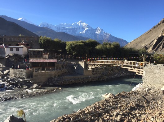
Gradually leaving Kagbeni behind we headed up the escarpment. It wasn’t long before the remaining duvet jackets were stowed as heads bowed to the uphill struggle. The path was steep and stony and although the path was clear it did not appear often used. Sandstone bluffs ahead were heavily eroded and our footfalls were softened by a thick covering of dusty sand. The sky was a beautiful cloudless deep blue throwing the crestline of the mountains into sharp relief while the bright sunshine picked out a flock of severfal dozen diminutive but impressivley horned black goats on the slopes below the crest.
Overhead Himalayan griffon vultures were circling. These vultures are found mainly in the higher regions of the Himalayas and is the largest and heaviest bird found in this region. While they may be seen perching on crags they are well camouflaged and as a result they are most often seen soaring in thermals. Due to their size and weight they are not capable of sustained flapping flight. Vultures typically follow grazers up the mountains in their search for dead anaimals as food so while we were admiring the flocks of goats from below the vultures had them in their sights from above.
After 3 hours of uphill toil under an increasingly searing sun we stopped for lunch. We had noticed that while Gyalbu and Sangye had made great progress uphill with the ponies the other 2 porters had been struggling. This didn’t cause concern at the time as this being our first day on the trek proper we were in no particlar hurry and we recognised that the junior Sherpas may need a day or two to shed cobwebs spun during lowland living. Despite their slowness we were pleased to find that when we reached Yak Kharka (which means yak resting place) and its tiny settlement just after 11 am the ponies had been unloaded, the support Shepas were there too, and lunch was being prepared. A woman who lived at the settlement had appeared. She was dressed traditionally in a dusty dark brown robe (over less traditional green slacks and decripit sandals), an apron striped with diagonal bands of red, black, blue, white, yellow and green, a dishevelled purple jacket and a red woollen hat. We saw a man too but he kept his distance. The woman was showing particular interest in our equipment and food and we learned later that she had attepted to gain payment for our use of ‘her’ water. Given that a gallon of water had been fetched from a nearby stream in a green bucket by Sangye her charges weren’t paid. We did however share some of our Chinese Wei Wei noodles with her and she left content.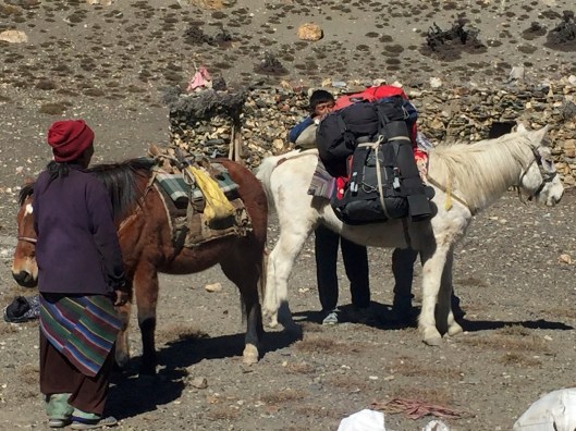
We were to find that lunch at or before midday was the norm on the trek. Due to the shortage of power for lighting and heating rural Nepalese people tend to make best use of daylight and we followed their excample. This meant taking breakfast with the dawn at around 6:30, lunch at around midday and the evening meal at the British tea time between 5 and 6pm. There are variations of course and not everyone is the same, but this was the rythym we were to get used to not least as when camping we would ideally put up the tents and have our evening meal before we lost daylight. Furthermore it was very cold in the late afternoon as the sun went down. All heat was from the sun and there was no residual heat in the ground. Typically in the mountains, or more precisely in the deep mountain valleys and gorges in which we normally found ourselves, we lost the sun as early as 3pm despite sunset not formally being until 5pm. As a result when camping we were normally in our sleeping bags by 7pm or even earlier.
After lunch we continued our ascent. Following the increasingly broken and difficult track northwest we found the support Sherpas dropping back again. While some of the trekking group hung back too, and Gyalbu felt obliged to stay with the rear group, I decided to follow the ponies with the horseman and Sangye up ahead. So it was that we came to the landslide area first.
At about the 4000m (13,000ft) mark we were happily following a fairly well defined but loose path. The slope above and below us was at around 45 degrees and while there were a few spindly trees and the occasional low scrub it was effectively scree. After a while we came to a section of the slope that had recently slipped. This was obvious as there was no track across it yet we could see where it continued on the other side, around 20 metres away. However, it wasn’t moving at that time and as there was no alternative route we decided to cross; very gingerly. The horseman went first with the ponies and had no problem. Sangye followed and likewise had no drama. Then it was my turn. I started off very carefully but when I was around half-way over while my section of the hill wasn’t moving another landslide had started above me, to my left, and if that continued then pretty soon the whole slope would slip. RUN!! yelled the normally quiet and reserved Sangye. SAH RUN!! he yelled again. Needless to say run I did, but not before being clouted on the left side of my head by a sizeable rock. Thankfully it caught me above the ear and I still had my TNF hat on which softened the blow. No harm was done and I wasn’t knocked over or out, but I fairly sprinted over the last few metres to the safe zone before, as feared, the whole slope slid. Here is a photo of the aftermath, taken while I was on the satphone to Clare. I didn’t mention my lucky escape but figured it was time to check-in and let her know what a great time I was having and everything was fine.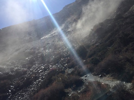
Following that, a few hundred metres later we unexpectedly came upon a wide track built for a vehicle. Quite why it had been built and where it started in the east we had no idea, but it was going in the right direction west and eased navigation issues for a while and we were glad to be able to get a decent pace going along it. Gaining height all the time we crossed an unnamed pass at 4306m (14,127ft) on the Jeula Danda ridge before reaching the Bhima Lojun La at 4460m (14,633ft). At this point Sangye, and the horseman with the ponies, continued while I climbed to the summit of Bhima Lojun itself. While at 4465m (14,649ft) it was hardly a major Himalayan peak it was nonetheless a summit not much lower than Mont Blanc. The wind was blowing a very cold gale on the summit and my 2 layers of clothing (green Rab Alpine Lite added to Trespass t-shirt) weren’t really up to the job so I waited until I got down a little before taking this shameless ‘selfie’ with the summit of Bhima Lojan in the background.
As it happened Tim, Jovi and Lizzie arrived as I got back to the Bhima Lojun La just before 3pm and we shared some snacks. A favourite biscuit was already developing: coconut crunchees! Despite the welcome rest Tim was concerned that our 2 support Sherpas were some way behind and we would be losing light in a couple of hours. At this stage there was no alternative but to press on. We certainly couldn’t camp at this height due to the exposure and our target remained a village still several miles away. This is the village I had referred to in my introductory blog ‘the first 5 days’ as ‘Santa’. I had learned by now that the trekking map I had used as my source wasn’t especially accurate. More correctly, it didn’t reflect the range of names that different Nepalese peoples give to the same place. Thus Santa was not recognised as a specific location, rather an area, and our intended resting place for the night was not called Santa at all but Pilling.
Once Bhima Lojun La was left behind we had a very cold late afternoon as we tried to make speed along the stony track coutouring around the mountain between snow-covered Tashikang to the south, at 6385m (20,948ft) the highest peak in the area and the reason we lost the sun so early, and the Kyalunpa Khola (Kyalunpa river) gorge to the north. Quite a few lessons were learned that afternoon about the right clothing for the environment and the importance of making good progress early so as not to get caught out in the dark.
Just before 5pm in the gathering gloom and with the wind whistling around us a loud rumble to our left, in the direction of Tashikang, caused heads to spin. A huge avalanche was pouring down the escarpment around 1 km to the south. It was sufficiently far away for us to be in no danger but it sure quickened our step.
Twenty minutes later we emerged from the huge shadow of the Sandachhe Himal ridge of which Tashikang is a part to be confronted by the village of Pilling. Perched on a plateau several hundered feet above the Kyalunpa Khola, Pilling was a complex series of squat, single-story austere stone dwellings and livestock compounds situated above many acres of terraced arable land surrounded by seriously tough mountains. Looking left, to the west, I could see the precipitous Kyalunpa gorge continuing towards and beyond the Jungben La, the massive pass that we would traverse a few days hence. Looking right, to the east, I could see the Kali Gandaki gorge from where we climbed out of Kagbeni 9 hours earlier. In front of me was Pilling, beyond it the gorge with the river invisible in its depth and on the opposite side was a deserted village with terracing, apparently clinging by its cold fingernails to the unbelievable steep mountainside. In the failing light the terrain looked foreboding nonetheless we investigated the village hoping to find a welcoming hearth and food so as to preserve our stocks. If not we would find a camping space for our tents. Tim and Gyalbu approached the village first in order to save the inhabitants from concern or obligation. While from our garb we expected that our purpose in the land was obvious, but brigands are not unheard of in these parts and we needed to be cautious.
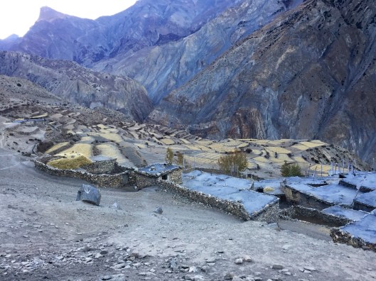
They returned shortly having found the village deserted. Every part of the village was neat and as clean as is normal for people who live cheek-by-jowl with their animals. There was fresh hay on some roofs and fresh-looking footprints in the dusty walkways. White prayer flags fluttered in the cold wind and nothing was overgrown or in disrepair. But the village was empty. Not a single person or animal remained. They had all gone, and quite recently too, possibly within the past few days.
As it was approaching 5:30 we made the decision to set up camp in one of the empty animal compounds. Kicking fresh animal droppings to one side tents were hastily erected with the help of head-torches while Gyalbu and his team, now at full strength following the belated arrival of the final 2, very tired, porters, set about preparing dinner in a corner of the compound in the gloom.
We had trekked around 20 miles on our first full day. This was significantly more than would have been possible without the additional acclimatisation day at Kagbeni and the use of ponies from the start. Add to that a vertical height gain of 1650m (5,414ft) from Kagbeni at 2810m (9,219ft) to the Bhima Lojun La at 4460 (14,633ft) and we had reason to be pleased with ourselves. We wolfed our dinner of chilli con carne and rice with black tea prepared by the amazing Gyalbu and Sangye and mostly slept well although Lizzie was cold during the night despite adding thermal layers. Given the overnight temperature was around freezing and that even the contents of pee bottles were frozen in the morning anyone without a good 4-season sleeping bag and decent thermal insulation beneath was going to suffer. I think most suffering was felt by the 2 support porters who we understood may not have prepared well enough, neither physically nor in equipment and clothing, for their work and were already making noises about returning to Kagbeni. If that were to happen then we would be carrying heavier bags very soon.
And so day 3 of the trek came to a close. We’d arrived at Pilling in the nick of time after an amazing day and had enjoyed hot food. We had tired legs but no injuries, and soon the only sounds around the compound were the bells on the necks of our restless ponies and (mostly) contented snoring. Plus the inevitable zip, zip, zipping that accompanied those needing to vacate their tent and dash behind a wall to accomplish things not feasible in a bottle.
Life had returned to a pitch black and very cold animal compound in the deserted village of Pilling for just one more night this year. Tomorrow we would move on, forever westward for the next few days at least.

Great blog Dad, hanging on your every word and looking forward to the next installment!
LikeLike
I’m writing it now and it’ll be posted tomorrow morning Vikki. Glad you’re enjoying it!
LikeLike
Brilliant Andy , feels like I am there with you ! …..you conjour up such a wonderful picture !
LikeLike
Thanks Jackie! X
LikeLike
Wow that was an exciting read! Rock to the side of the head??? Sounds interesting! Can’t wait for the next installment
LikeLike
It’s nearly done and will be published tomorrow morning Simon. No more rocks to the head this time though.
LikeLike