
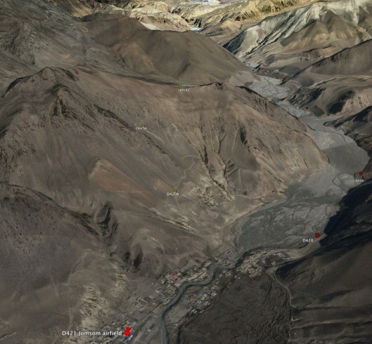
On Friday 4th November (day 1) I expect we will trek to Dagarjong (3229m/10,594ft) but that is not yet certain. By the time we depart Jomsom we shall need to have decided whether to go via Kagbeni or not. My current understanding from Tim is ‘not’ as this will save us a little distance and by gaining a little height will assist our acclimatisation. Jomson sits at around 2700m and our first intended camp is at Dagarjong (3229m), a modest gain of 600m. As we gain height Jomsom and the Kali Gandaki Nadi valley will become smaller and more distant, as will memories of comfort and lungs full of rich air. We won’t see the target for the night until we crest the ridgeline that stands between Jomsom and Dagarjong at which time the outskirts of Kegbeni will appear down in the valley to our right and we shall be over half way through our first day. Dagarjong and a neighbouring village, Phalyak, lie either side of the Kolungba Khola (Khola is river in Nepali). Should matters be progressing better that we anticipate we could contunue another few miles to the campsite at Yak Kharka, or above it alongside the Rataula Khola (river) at around 3500m, a height gain of 800m, having crossed the second ridge at around 3840m and then descended to the camp. This would be a total distance of around 10miles; quite a lot for our first day at this altitude.This first picture shows a birds-eye view of our route up to the first ridgeline via the yellow waypoints D420b, D421b and D422b. Yak Kharka is beyond the second ridge. Should we elect to head for Kagbeni we will instead follow the red markers to the right of the river valley.
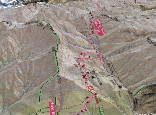
An alternative view is provided with the terrain overlaid with the trekking map which shows our path (the black dashed line) over the first ridge. Should we continue to Yak Kharka the path can be seen heading over the second ridge too.

As for day 2 of the trek, on Saturday 5th November we will head for Sangda (or Santa depending on which map you use) at 3777m/12,392ft. We expect that to be around 6 hrs of trek depending on where we halted for the previous night. The most notable aspect of the trek to Sangda/Santa is that we will cross a pass that isn’t named at 3810m and then one that definitely is, the Bhima Logan La at 4460m, only just short of the summit of Bhima Logan itself at 4465m. No chance that we’ll pop up there of course! The next 2 pictures give you the gist of where we’re headed over the next few days. You may notice that in a few cases the waymarkers are not exactly on the pink/white route on the map. This is because from my examination of the Google Earth arial photographs the map is not exactly right. In many cases it is, but not always, so the waymarkers are true to the ground rather than the map.
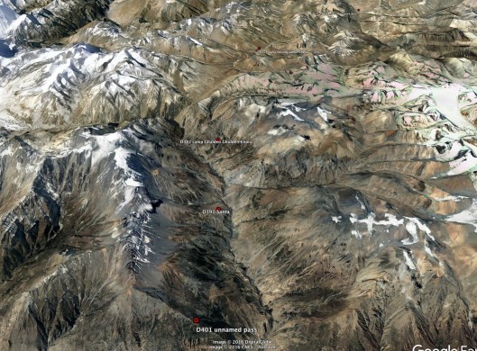
On Sunday 6th November (day 3) we will trek to Gyalchen Khola (4247m/13,934ft) for 4 to 5 hrs. After we pass the village of Jhansye at 4195m we will follow the Kyanlunpa Khola valley to Gyalchen Khola (marked on the map as Ghalden Ghulden Khola camp) at 4247m where we spend the night. Then early on day 4, on Monday 7th November, we will cross the Lhanhimak Khola and then scale the massive Jungben La at 5550m. This will be a big challenge so soon after leaving Jomson almost 2km lower and if any trekker is to falter I think they will do so here, or before.
Any of the team still able to continue will then face the relatively easy crossing of the Niwas La (5120m) before descending moderately to the Thasan Khola and follow it to our camp for the night at Nulungsamda Kharka (4987m/16,362ft); a journey of around 7 hrs on Monday 7th November.
On Tuesday 8th November, day 5, we continue down the Thasan Khola valley to Chharka Bhot. At 4302m/14,114ft this is another 7 hours or so of trek. Chharka is a village which, unusually, appears on Wikipedia. Wikipedia shares that at the time of the 2001 Nepal census there were a total of 634 people living in Chharka. Over one third of the population were in the age group of 4–19 years of age while only roughly about 9% of the population were the age of 50 or over. Clearly not a place for longevity – it must be so hard to live let alone thrive at this altitude.
Having covered roughly the first 50 miles of trekking in the first week, in my next blog I’ll bring you up to speed on our plans for feeding ourselves before returning to the trek route in due course.

Maps not easy to understand but snow depth permitting the ridge route looks less exhausting – but what do I know having only walked a ridge in the Tyrol 60 years ago!
LikeLike
If you mean the green line Rex I believe that is a district boundary. I agree ridge routes offer stunning views but we need to stay close to habitation, food and water given we can carry all our food from the start.
LikeLike
You seem to be cracking on well. Sad about the Yorkshire lad who with his team failed to get further than Camp 2 on Everest because his blood was turning to treacle. At least it was a success scientifically though. I meant to ask but forgot, are you having to return the same way to get home ? I hope not
LikeLike
No retracing of steps Rex.
LikeLike